


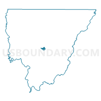
Precinct 30, Morehouse Parish, Louisiana
About
Outline

Summary
| Unique Area Identifier | 589679 |
| Name | Precinct 30 |
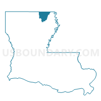
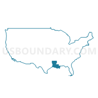
| County | Morehouse Parish |
| State | Louisiana |
| Area (square miles) | 1.17 |
| Land Area (square miles) | 1.17 |
| Water Area (square miles) | 0.00 |
| % of Land Area | 100.00 |
| % of Water Area | 0.00 |
| Latitude of the Internal Point | 32.76989370 |
| Longtitude of the Internal Point | -91.81159540 |
Maps
Graphs
Select a template below for downloading or customizing gragh for Precinct 30, Morehouse Parish, Louisiana


Neighbors
Neighoring Voting District (by Name) Neighboring Voting District on the Map
- Precinct 28, Morehouse Parish, LA
- Precinct 29, Morehouse Parish, LA
- Precinct 31, Morehouse Parish, LA
- Precinct 52, Morehouse Parish, LA